Oct 06 2021
Networking

Street Smarts: How Sensors Help Virginia Beach Monitor Its Environment

Tech tools help the city monitor traffic and the environment to benefit visitors and residents.

Virginia Beach’s 2016 U.S. Department of Transportation Smart City Challenge application envisioned the city in 2045 would be viewed as a well-planned community where “neighborhoods and residents will be interconnected” — hopefully “the most livable coastal community in the world.”

Although the southeastern Virginia city is still more than 20 years away from reaching that target date, the city appears to be on its way to making that vision a reality, with recent smart tech implementations offering timely flooding risk information, increased internet access and other quality-of-life benefits.

Through a data-sharing partnership announced in 2019, for instance, Virginia Beach provides transportation mobile app Waze with planned construction and road closure data to share with its users, along with parking information from Wi-Fi-enabled sensors situated in and above spaces in the city.

As part of the initiative — which received a Smart Cities Connect 2021 Smart 50 Award, given to recognize projects that will have the most municipal impact — Waze supplies Virginia Beach with real-time traffic insight culled from its users.

The city is also able to provide emergency-related notifications through the app about major traffic and other events — such as the annual Something in the Water three-day music festival, which can bring 65,000 people to the city’s beachfront daily, according to the city’s CIO, Peter Wallace.

“That’s a lot of people coming to the area,” Wallace says. “Anyone can know where closures are, if there’s an accident, where parking is before they head down to any part of the event.”

Smart Tech Installations Augment Connectivity

In late 2020, the city installed two 24-foot solar-powered smart poles outfitted with LED lights and a Verizon network connection, which function as hotspots to expand broadband Wi-Fi access in a several-hundred-foot radius within the Lake Edward neighborhood and near the city’s Pungo-Blackwater Library, Wallace says.

“Those were picked because they were underserved neighborhoods that don’t have broadband capabilities or can’t afford it,” he says. “That issue showed up during the pandemic, when kids were home with their school-issued Google Chromebooks and had to go to class remotely. Prior to that, we saw a lot of traffic at the library location, where kids were hanging out in the evening doing their homework. So, we figured, why don’t we help by extending connectivity to that location?”

Increasing digital equity, according to Mayor Bobby Dyer, is a priority for the city.

“We have districts, the ocean, a city square, farmland — and one of the things we’re concerned about is being able to connect with everyone,” Dyer says. “We’re very cognizant of the underserved community we have, and that’s why we’re putting in smart poles. We want people to have access.”

RELATED: How are cities and states expanding Wi-Fi access for citizens?

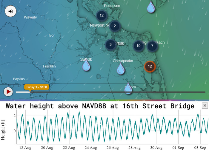
StormSense Monitors Flood Levels for Virginia Beach

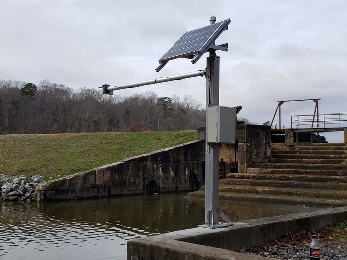
Virginia Beach uses smart technology to help gauge and respond to coastal flooding as part of the StormSense initiative, a collaborative effort between several municipal governments and William and Mary’s Virginia Institute of Marine Science.

Funded in part by a 2016 National Institute of Standards and Technology grant, the project leverages data culled from Internet of Things sensors, deployed in locations such as bridges, that actively send out pulses and measure how far a target or object is from the sensor, says Derek Loftis, research assistant professor at VIMS’ Center for Coastal Resources Management.

Along with U.S. Geological Survey and National Oceanic and Atmospheric Administration sensor data, information from the project’s ultrasonic sonar and radar sensors is used to convey current conditions and perform hydrodynamic flood modeling and forecasting.

Virginia Beach Storm Sense

The StormSense system provides information on water levels in and around the city. Source: City of Virginia Beach

The sensors are completely autonomous and provide data on the water level at locations every six minutes, says Sridhar Katragadda, a data scientist for the city.

“The ultimate goal is to see sea level changes in Virginia Beach and the surrounding region and be able to predict how the water is changing and how the landscape is changing over time,” Katragadda says.

Residents can view an interactive map with real-time water level information via StormSense’s platform or verbally request an update on the water level in a certain location from an Amazon Alexa-enabled device or from the Reverb app on an iPhone or other smartphone.

“StormSense has integrated all the data that cohesively represents what’s happening in the community,” Loftis says. “It’s basically a low-latency way to check what levels are, if residents find themselves without internet or power.”

MORE FROM STATETECH: Find out how smart city tools can improve community safety.

Virginia Beach Eyes Better Traffic Management Through Tech

Although the COVID-19 pandemic slowed down some of the city’s smart tech plans, Virginia Beach is still considering implementing several initiatives.

The city could potentially publish an interactive map of which roads are plowed during a snowstorm and which will be cleared next, Wallace says. It may also eventually use sensors and its 133-mile fiber network to connect traffic lights and emergency vehicles, enabling them to reach accident sites faster.

Virginia Beach Storm Sense

StormSense sensors provide data on the water level at locations every six minutes. Source: City of Virginia Beach

Dyer, who notes technology has advanced at a dizzying pace in the years since he was a doctoral candidate and carried a beeper, says he knows that speed isn’t likely to slow down anytime soon. Keeping up with the latest options, he says, will be an ongoing effort. However, Virginia Beach is committed to being on the forefront of smart tech adoption.

“We have to play chess, not checkers — identify what technology is going to be out there in four to five years and start capitalizing on it now,” Dyer says. “What is going to get us to the future in a positive way is going to be the technology and the fact that we’re going to be able to engage our citizens. They’re going to get the information from us they need, and that creates the win-win scenario we want.”

DenisTangneyJr/Getty Images
Close

Become an Insider

Unlock white papers, personalized recommendations and other premium content for an in-depth look at evolving IT